I have been saving this title!But I came up with it before
I realised just how far it was! Not so much in miles but in time! The distance
from Huanuco (where the good road starts) to Puno on Lake Titicaca is 1,240
miles, so in terms of the mileage done to date is a drop in the ocean. And
unlike the road from Chavin to Huanuco before it (187 of the worst pot holed miles
I have driven) this was all tarmac, but constantly up to over 4000m, down to
under 2000m and then back up again, and of course on very windy and often
single track roads, taking 9 very tiring days (excluding rest days). We took
time out at Ayacucho, which had very bad reports, but we loved it and ended up
staying 2 nights. Both nights we ate on a balcony overlooking the Plaza de
Armas (main town square), with good food and an excellent view.
After Ayacucho we pushed on again, up and down, round and
round, often climbing an descending over 7,000 metres per day, until finally we
stopped at a small site on IOverlander called Casa Lena, supposedly for one
night but stayed for 3 Casa Lena is in fact a school for deprived and special
needs children from the local area, the camp site (and B & B) is to help support
the school. Run by a young Belgian lady with amazing energy, her Peruvian
husband and 2 small children. Stephanie (I won't go into why it is called Casa
Lena) was a special needs teacher in Belgium, came to Peru to do some voluntary
work, met her husband and here they are 5 years later, having built the house
and the school from scratch. She now takes volunteers from Belgium training to
be special needs teachers so helps both them and the local children. The views
from the site are spectacular and there is a walk from the town (Curahuasi) up
to a 3,200m peak with look-out points to an amazing Canyon below (arguably one
of the deepest in the world). In fact it was very hard to only spend 3 nights
there. From there we drove to Olantaytambo, taking a short cut over a dirt road
round the most amazing lake, with snow capped peaks in the distance.
Olantaytambo for me has to be one of the main highlights of
the trip. Part of the inspiration for this whole trip was our visit to Peru for
Chris’s 50th birthday. This was an organised trip where everything was
scheduled and whilst very good you can’t vary from the plan or stay somewhere a
bit longer. Olantaytambo was definitely one of those places I wanted to stay
longer and happened to be the place where this trip intercepted the one we did
11 years ago and I finally got to walk up to the Inca Granary way up on the
cliff face I remembered from our first visit. The town itself is quite
amazing as it has been inhabited continuously for 700 years, since Inca times
and the bases of all of the houses, including the majority of doorways and
windows, are original Inca stone work.
Chris was not feeling too good on our first day at
Olantaytambo and elected to stay back at camp and rest, whilst I hiked up to
the Granary, walked every corner of the village and then round the main
archaeological site. After which I spent most of the night trying to work out
how to get my head and my backside over the toilet at the same time, so next
day I was laid up for the whole day!
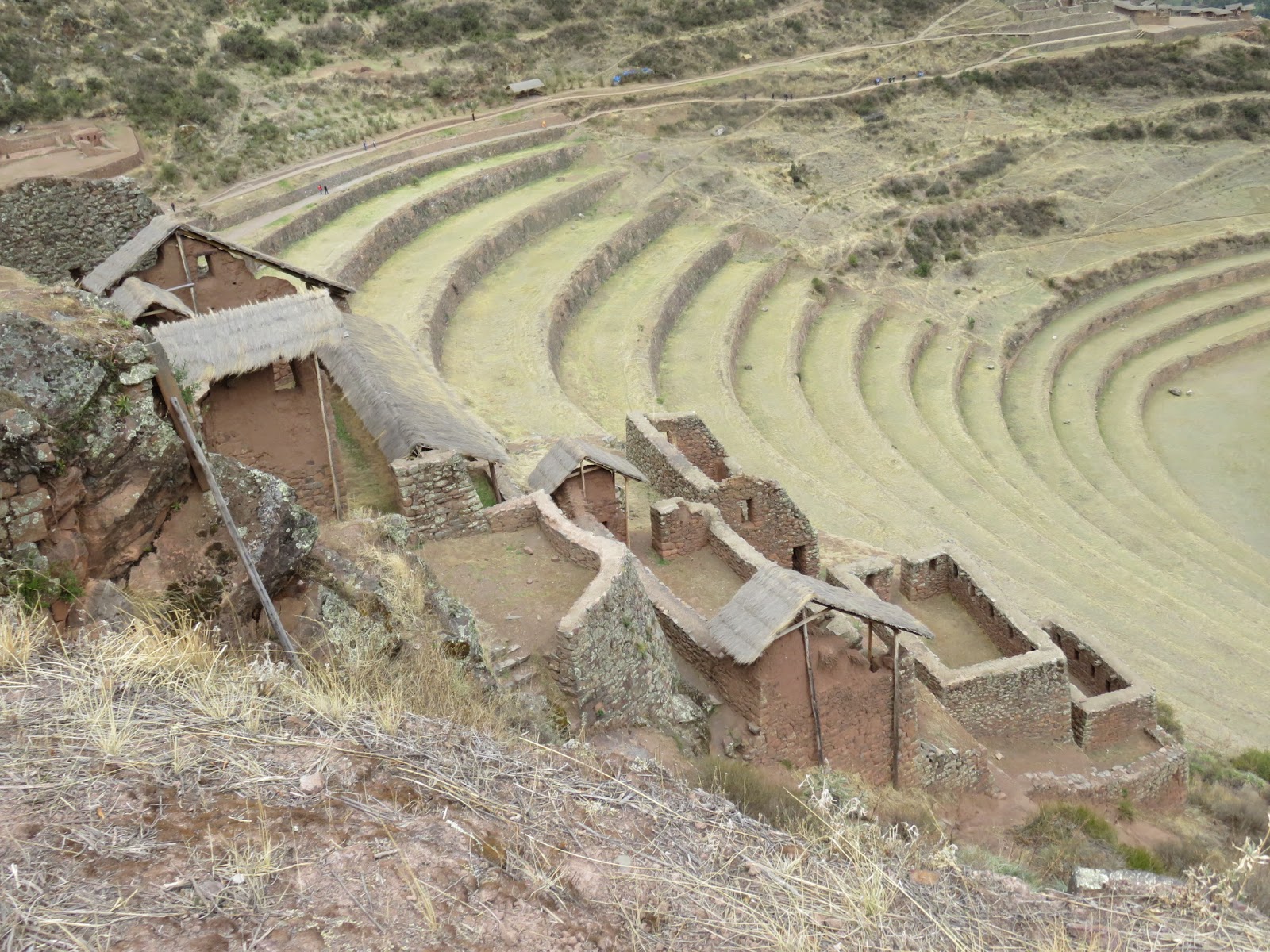
Next was another Inca site called Pisac, with fortifications
on various parts of the mountain guarding 3 different valleys. Chris decided
against doing the whole circuit and I wished I hadn’t about ¾ round! After
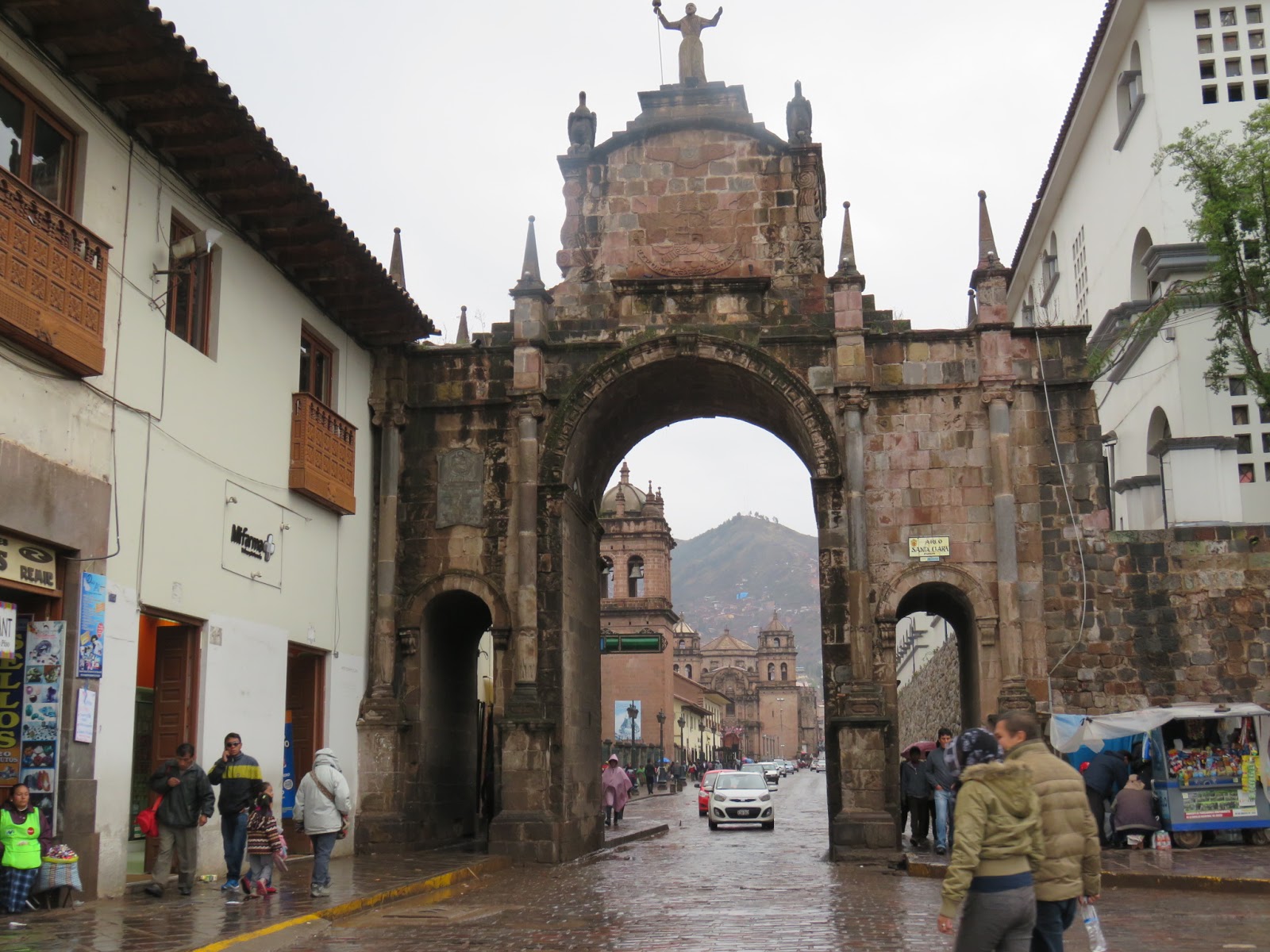
which we drove to Cusco. Cusco is a major city, again with lots of Inca walls
and buildings based on Inca foundations, but for me not as good as
Olantaytambo, in fact the most impressive place in Cusco was the Irish pub ‘Paddy’s
Bar’, we initially went there for the full Irish breakfast, but ended up
spending most of our time there as it started raining about midday and just got
heavier and heavier and although the Guinness brewery will no longer deliver
draft Guinness they have a local stout which is almost as good.
From Cusco we followed the train tracks over the Andes to
Puno on Lake Titicaca, remembering the train that we had taken 11 years ago. On
the itinerary this just looked like another mode of transport but in fact
turned out to be one of the highlights of the trip and unlike many of the other
roads we have driven this is a very gradual rise up to 4,350m at the top and
gradually back down to Puno at 3,800m, covering a distance of over 200 miles.
We are now at the far end of Lake Titicaca at Copacabana,
having crossed into Bolivia this morning, achieving another goal from 11 years ago, where from Puno we could see Bolivia and now we are here!
 |
| A Lake high in the mountains |
 |
| Pisco Sours on the Terrace in Ayacucho |
 |
| The Plaza de Armas in Ayacucho |
 |
| The town in centre picture is over a mile below. |
 |
| Our camp spot at Casa Lena |
 |
| Ther view from our camp spot |
 |
| A tough walk up in altitude but an amazing view of arguably the deepest canyon in the world |
 |
| Stephanyie and the latest addition to the familly |
 |
| Amazing skies |
 |
| We take a short cut on a dirt road |
 |
| Round another beautiful lake |
 |
| Then back onto a good road to Olantaytambo |
 |
| Olantaytambo |
 |
| The original Inca Foundations |
 |
| and doorways |
 |
| A couple of locals on their way to sell thier wares to the tourists |
 |
| The photo I took 11 years ago |
 |
| And after 11 years I am almost at the Inc Granary |
 |
| Taken from the Granary with a view of the ruins in the background |
 |
| Pisac, another Inca Site |
 |
| Unfortunatley they no longer have Guiness |
 |
| But they did do a good Irish Breakfast |
 |
| I'll save this for later |
 |
| Cusco, the rain has just eased off a bit |
 |
| Another Inca site |
 |
| Following the reilway over the Andes |
 |
| After a few days of rain we had blue skies for the drive over. |
 |
| I could not decide which pictures to take out |
 |
| So left them all in |
 |
| After Puno we take a dirt road detour round a peninsular on the way to Bolivia |
 |
| and find a really clear bay |
 |
| Then continue round the peninsular, no tourists (other) here. |
 |
| Then back on the road to Bolivia |
 |
| Lake Titicaca from the Bolivian end |
 |
| Copacabana, Bolivia |


